Corridor Connect helps transportation agencies and their partners make better use of the data they already collect.
Transportation information comes from many sources, including state transportation systems, traffic sensors, drones, weather services, commercial vehicles, and navigation applications. These systems often use different formats, making it difficult to process, and combine information and understanding conditions across state boundaries.
Corridor Connect links to existing systems rather than replacing them. It helps users find available data, assess its quality, understand differences between sources, and combine information to create a more complete picture of transportation conditions.
Users can explore information across corridors, compare conditions, investigate discrepancies, research specific topics, and develop reports, maps, and data feeds that support better decisions.
The platform also creates opportunities for technology companies, researchers, and other partners to develop new applications using shared transportation information.
The goal is simple: Make existing transportation data more useful across systems, organizations, and state boundaries.
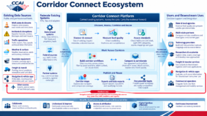
The Corridor Connect Ecosystem diagram illustrates how transportation data moves from existing sources through the Corridor Connect platform to support decision-making processes, collaboration, and new applications.
The ecosystem begins with information already collected by transportation agencies and their partners. Sources include work zones and road closures, incidents, hazards, traffic conditions, weather, roadside equipment, freight and transit systems, navigation applications, and other transportation-related systems.
Corridor Connect links to existing state and local systems, federal data sources, agency data warehouses, data bases, and commercial partners.
Information can enter the platform through APIs, files, and other interfaces in different formats. Participating organizations do not need to replace their existing data systems or standardize all their information before connecting.
The platform supports three groups of activities:
State and local agencies, multistate partnerships, technology providers, researchers, freight and traveler services, navigation applications, and commercial operators can use the information produced through Corridor Connect.
Navigation and vehicle applications can also contribute information back to the ecosystem, creating a feedback loop that continuously helps to improve transportation data.
Security, governance, and operations support the entire ecosystem. These capabilities include collaboration, data quality improvement, access controls, share data agreements, source attribution, and continuous improvement.
A planned Digital Sandbox will provide a secure environment for industry and researchers to test and validate new solutions.
Corridor Connect is not a replacement for existing data exchanges or agency systems. It is a way to connect them, understand their information, process it, and make that information more useful for improving road operations and mobility in those corridors.
What is Corridor Connect? | Corridor Connect is a shared platform that helps transportation agencies and their partners link existing data sources, assess information quality, and use data across systems and state boundaries. It helps turn information from many sources into maps, graphics, tables, reports, workflows, and documented data feeds that support better transportation decisions. |
Why is Corridor Connect needed? | Transportation information is often spread across agencies, systems, and jurisdictions. Even when information is available, differences in formats, quality, and definitions can make it difficult to use together. Corridor Connect helps overcome these barriers, so users can better understand transportation conditions across an entire corridor. |
How does Corridor Connect support CCAI? | Corridor Connect supports the Connected Corridor Advancement Initiative’s goal of improving transportation coordination across state boundaries. It provides an environment where agencies and partners can examine corridor data, identify gaps, and develop shared approaches. The platform supports—but does not replace—the partnerships, operational practices, and governance needed for coordinated corridor operations. |
Is Corridor Connect another data exchange? | No. Corridor Connect is designed to work with existing data exchanges, agency systems, and data warehouses, and not replace them. It provides tools to discover, assess, combine, and reuse information from those systems. Agencies can continue operating their existing infrastructure while making their data more useful to others. |
Does Corridor Connect replace state transportation management systems? | No. State and local agencies continue using their existing traffic management, traveler information, incident and hazard management, weather, and other operational systems. Corridor Connect links information from these systems to support activities that cross organizational or geographic boundaries. |
Who is developing Corridor Connect? | Corridor Connect is being advanced through the Connected Corridor Advancement Initiative (CCAI), a multistate transportation pooled funded study, with the assistance of the United States Department of Transportation (USDOT). CCAI brings participating agencies and partners together to address shared data challenges, experiences, and develop practical approaches to connected corridor operations. |
What makes Corridor Connect different? | Corridor Connect brings several capabilities together: connecting existing systems, accepting data in different formats, measuring data quality, assessing standards, building cross-state workflows, and publishing reusable outputs. It emphasizes understanding the source and quality of information rather than simply moving data between systems. |
| Is Corridor Connect the same as the INODE Proof of Capability developed by USDOT? | No. Corridor Connect builds on the capabilities demonstrated through the USDOT Integrated Network of Digital Exchanges (INODE) Proof of Capability (PoCa). INODE demonstrated how transportation information from different systems and jurisdictions could be connected, assessed, and used together. Corridor Connect represents the next step: transitioning these demonstrated capabilities into a practical, sustainable platform advanced by CCAI. While INODE established the technical foundation, Corridor Connect will focus on operational implementation, expanding participation, and supporting real-world transportation needs across state boundaries. |
Does data need to be standardized before entering Corridor Connect? | No. Corridor Connect is designed to accept information in multiple formats through APIs, files, and other interfaces. Its discovery, mapping, and assessment processes help users understand how different sources relate to common data standards. Data can be evaluated and prepared for consistent downstream use within the platform.
|
How does Corridor Connect handle data quality? | Corridor Connect supports checks of data availability, freshness, completeness, and alignment with applicable standards. These assessments help users understand the strengths and limitations of a source before using it in decisions, reports, or applications.
|
Which data standards does Corridor Connect support? | The ecosystem identifies standards such as Work Zone Data Exchange (WZDx), Connected Work Zone (CWZ) draft specifications, and DATEX II. The platform’s standards assessment functions help users identify differences, document mappings, and understand where information does or does not align with relevant specifications.
|
Does Corridor Connect store or own state data? | Connecting to Corridor Connect does not, by itself, transfer ownership of data. Participating organizations retain their existing ownership and control responsibilities. The specific handling of data, including any storage, retention, permitted use, or redistribution, must be established through applicable agreements and platform policies.
|
Can Corridor Connect use commercial or proprietary data? | The architecture supports connections to commercial providers and other permissioned sources. Whether data can be accessed, combined, or redistributed depends on the provider’s permissions, licensing terms, and applicable agreements.
|
| How does Corridor Connect protect sensitive information? | Security and access management are part of ecosystem design. The platform includes authenticated access, role controls, credentials, and source attribution. Specific protections and permissions must be implemented according to the type of data and applicable security requirements. |
| What does source attribution mean? | Source attribution helps users identify where information originated and understand the evidence supporting an output. This is important when data comes from multiple agencies or providers, particularly when sources disagree, or decisions require further review. |
Does Corridor Connect require states to build new data warehouses? | No. Corridor Connect is designed to connect with existing data infrastructure, including agency warehouses, data exchanges, and other systems. A participating agency’s integration needs will depend on the data it wants to share, and the interfaces already available. |
What do quality scores and standards assessments tell users? | Feed-quality metrics help users understand characteristics such as availability, freshness, and completeness. Standards assessments examine how information relates to a selected target format or profile, identifying usable information, mapping needs, and gaps. These results support improvement and informed use. They are not official certification, a ranking of agency performance, or a guarantee that every observation is correct. A missing field or unobserved event category also does not necessarily mean the agency lacks that information elsewhere. |
How does Corridor Connect combine and corroborate information? | Users can build workflows that bring multiple sources together, filter by location and time, and examine agreement, differences, and supporting evidence. For example, a workflow might compare agency and partner work-zone reports, then add traffic or roadside information. Source identity and processing context help explain the result. Nearby information is not automatically proof: corroboration depends on defined rules and the evidence available. |
Who can benefit from Corridor Connect? | Potential users include state and local transportation agencies, multistate partnerships, technology providers, navigation companies, connected vehicle developers, commercial freight operators, researchers, nonprofit organizations, strategic coalitions, private-public partnerships, and traveler information services. Each may use the platform differently, depending on its needs and permissions. |
What kinds of transportation information can be used? | Examples include work zones, road closures, incidents, hazards, traffic conditions, travel times, weather, roadside equipment, freight and transit information, crashes, incidents, and selected information from navigation applications or other partners. Availability depends on connected sources and data-sharing permissions. |
How does Corridor Connect support interstate travel? | Transportation conditions do not stop at state lines. Corridor Connect helps users bring together information from multiple jurisdictions, compare conditions, and investigate gaps or conflicts. This can support a more consistent understanding of events/incidents that affect travel across a corridor. |
How can private technology companies use Corridor Connect? | Technology providers can use documented outputs, mappings, and source evidence to develop or improve applications. Potential uses include navigation, freight services, traveler information, data quality tools, and connected vehicle applications. Access to specific information is subject to applicable permissions. |
| How does Corridor Connect support connected and automated vehicles? | Connected and automated vehicle applications depend on timely, reliable information about the roadway environment. Corridor Connect can help improve access to information such as work zones, lane closures, incidents, hazards, weather, climate change, and changing conditions. It is not a vehicle control system and does not replace onboard sensing or vehicle safety functions. |
| Can navigation applications provide information back to Corridor Connect? | The ecosystem includes a feedback loop through which navigation and vehicle applications can contribute information such as probe data, traffic conditions, and user reports. This information can help agencies and other users compare observations with existing sources, subject to permissions, authorizations, and quality checks. |
What can researchers do with Corridor Connect? | Researchers can use available corridor information to investigate data quality, cross-state consistency, transportation conditions, and new analytical approaches. The ecosystem also identifies opportunities to test and validate solutions in a planned Digital Sandbox. |
| What outputs can Corridor Connect produce? | The architecture includes corridor maps, comparison overlays, reports, data exports, and documented feeds. Examples include GeoJSON exports and evidence-qualified connected work zone outputs. The availability of individual outputs depends on implementation and connected data sources. |
Is everything in the ecosystem diagram available today? | The diagram includes demonstrated capabilities, potential connections, downstream uses, and planned development. Availability and readiness vary by deployment, source, and use case. |
Must an organization be a CCAI member to use Corridor Connect? | CCAI membership and platform access are separate questions. The ecosystem is intended to support a broad community of public and private users, but access arrangements, eligibility, and permissions will depend on the participation model established for the platform. |
Does an agency need to replace existing software to participate? | No. The architecture is based on connecting existing systems. An agency may need to configure an interface, identify an appropriate feed, or establish data-sharing permissions, but replacing its existing transportation management software is not a prerequisite of the concept. |
Can an organization participate as a data consumer without contributing data? | The ecosystem distinguishes data sources from downstream users, allowing for different participation roles. Consumer-only participation is a potential model, subject to future access policies and agreements. Not every organization needs the same technical responsibilities. |
Will agencies lose control of how their information is used? | Corridor Connect is designed around governed access and reuse. Data owners and providers retain their established responsibilities, while specific permissions, permitted uses, and redistribution rights are addressed through agreements and platform controls. |
What is the cost of participating? | Participation costs will depend on an organization’s role, its existing technology, integration requirements, and the future operating and funding model. A universal participation fee or cost structure should not be assumed until these arrangements are established. |
How can an organization get involved? | Interested agencies, technology providers, researchers, and other partners can engage with CCAI to discuss use cases, available data, integration needs, and collaboration opportunities. Specific participation pathways will be communicated as the program develops. |
Is Corridor Connect fully operational today? | Corridor Connect is being advanced from demonstrated capabilities toward a broader operational platform. The ecosystem diagram represents the intended platform functions and supporting services, including capabilities that are still planned or under development. Availability should be confirmed for each specific feature.
|
What is the Digital Sandbox? | The planned Digital Sandbox is a secure testing environment where private industry and academic researchers can develop, evaluate, and validate solutions using Corridor Connect information. Its purpose is to support innovation without requiring experiments to take place directly in live transportation operations.
|
Is Corridor Connect a replacement for commercial mapping or navigation platforms? | No. Corridor Connect is intended to complement these services by making transportation information easier to discover, evaluate, and reuse. Commercial providers can be both consumers of Corridor Connect outputs and contributors of useful observations.
|
Will Corridor Connect make transportation decisions automatically? | Corridor Connect is designed to support better-informed decisions through data discovery, analysis, comparison, technical information, and reusable outputs. It does not replace the operational authority of transportation agencies or automatically direct traffic management, vehicles, or emergency response.
|
How will Corridor Connect improve over time? | The ecosystem includes collaboration, data quality review, source attribution, permanent feedback, and continuous improvement. Feedback from participating agencies, technology providers, researchers, experts in the field, and other users can help identify gaps, setbacks, refine standards, and guide future and improved/better development.
|